Ankpa
| Ankpa | |
|---|---|
 Location in Nigeria | |
| Coordinates: 7°26′N 7°38′E / 7.433°N 7.633°ECoordinates: 7°26′N 7°38′E / 7.433°N 7.633°E | |
| Country |
|
| State | Kogi State |
| Headquarters | Ankpa Town |
| Area | |
| • Total | 1,200 km2 (500 sq mi) |
| Population (2006 census) | |
| • Total | 267,353 |
| Time zone | WAT (UTC+1) |
| 3-digit postal code prefix | 270 |
| ISO 3166 code | NG.KO.AN |
Ankpa is a Local Government Area in Kogi State, Nigeria. Its headquarters are in the town of Ankpa on the A233 highway in the west of the area at7°22′14″N 7°37′31″E / 7.37056°N 7.62528°E.
It has an area of 1,200 km² and a population of 267,353 at the 2006 census.
The postal code of the area is 270.[1]
The northeasterly line of equal latitude and longitude passes through the LGA.
References
- ↑ "Post Offices- with map of LGA". NIPOST. Archived from the original on 7 October 2009. Retrieved 2009-10-20.
State capital: Lokoja | ||
| LGAs | 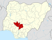 | |
This article is issued from Wikipedia - version of the 10/14/2016. The text is available under the Creative Commons Attribution/Share Alike but additional terms may apply for the media files.