Amsoldingersee
| Amsoldingersee | |
|---|---|
 | |
| Location | Canton of Berne |
| Coordinates | 46°43′26″N 7°34′37″E / 46.72389°N 7.57694°ECoordinates: 46°43′26″N 7°34′37″E / 46.72389°N 7.57694°E |
| Type | natural |
| Primary inflows | Rotmoos-Bach |
| Primary outflows | Wahlenbach |
| Catchment area | 4.202 km² |
| Basin countries | Switzerland |
| Max. length | 1.1 km |
| Max. width | 0.5 km |
| Surface area | 0.381525 km² |
| Max. depth | 13.9 m |
| Water volume | 2,552,682 m³ |
| Surface elevation | 641 m |
| Settlements | Amsoldingen |
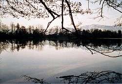
Amsoldingersee is small lake adjacent to the town of Amsoldingen, in the Upper Gürbetal. It is located near the city of Thun, Switzerland. The lake has a surface area of 38 hectares and a maximum length of 1.1 km and width of 500 m. The maximum depth is 14 m. It is fed by Rotmoos-Bach from the smaller Uebeschisee.
This article is issued from Wikipedia - version of the 11/21/2015. The text is available under the Creative Commons Attribution/Share Alike but additional terms may apply for the media files.